


A Hurricane Watch, Wind Warning and Rainfall Warning have all been issued for all of Nova Scotia.
Here’s the breakdown…
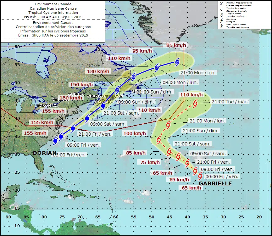
The Canadian Hurricane Centre says Hurricane Dorian will begin to race towards Atlantic Canada later today – severe impacts across the region during the weekend. as of 3 a.m. ADT Dorian was located approximately 185 kilometres southwest of Cape Hatteras with maximum sustained winds: 157 kilometres per hour and moving northeast at 25 kilometres per hour.
According to the latest forecast, the most likely track projection brings Hurricane Dorian south of the Maritimes on Saturday, pushing through eastern Nova Scotia Saturday night, and then over the eastern Gulf of St. Lawrence waters or western Newfoundland by Sunday morning.
Severe winds and torrential rain will have major impacts for southeastern New Brunswick, Prince Edward Island, Nova Scotia, Western Newfoundland, and the Quebec Lower North Shore. Large waves are expected for the Atlantic coasts of Nova Scotia, Newfoundland and for eastern portions of the Gulf of St. Lawrence. Finally, storm surge, combined with large waves and pounding surf, may give flooding for parts of Nova Scotia, Prince Edward Island, Newfoundland, and the Magdalen Islands.
WIND:
Most regions will experience tropical storm force winds of 90 to 110 km/h, beginning over southwestern Nova Scotia Saturday morning, in the afternoon over eastern Nova Scotia, and towards evening for Prince Edward Island, the Magdalen Islands, and southwestern Newfoundland. Near and to the south of the forecast track, winds will reach hurricane force of 120 km/h or more. Behind the storm, there is a possibility of hurricane force northwesterly gusts. Wind impacts will likely be enhanced by foliage on the trees, causing broken branches and tree falls, resulting in power outages, blocking of roads, and other type of damages.
RAIN:
Rainfall will be a major factor as torrential rain may lead to flooding. The highest rainfall amounts are expected over Nova Scotia, Prince Edward Island, and the Magdalen Island where 50 to 100 mm are expected. Forecast guidance is also suggesting a swath in excess of 150 mm north and west of Dorian’s track. Some districts have received large quantities of rain last week, and with the soil moisture still very high, excessive runoff may exacerbate the flooding potential. This combined with the severe winds may result in damage due to falling trees.
SURGE/WAVES
There will also be some rough and pounding surf, especially for parts of Nova Scotia, Newfoundland and the Gulf of St. Lawrence. Large waves will reach the Southwestern Shore of Nova Scotia on Saturday and build to near 10 metres over the Eastern Shore Saturday night. These waves will likely reach southern Newfoundland by Sunday morning. Waves near or higher than 5 metres will impact north facing coasts of the Gulf of St. Lawrence. Note that waves will break higher along some of the coastlines, and dangerous rip currents are likely. Please exercise extreme caution.
Storm surge is possible, mainly for the Atlantic coast of Nova Scotia, the north coast of Prince Edward Island, southwestern Newfoundland, and the Magdalen Islands. Current guidance suggests water levels approaching inundation levels during high tide. However, when combined with rough and pounding surf, there may be flooding and overwash of waves. Warnings may be issued later today.
Hurricane force wind warnings are in effect for southern and eastern waters of the Maritimes.
As Dorian moves into our waters, it will spread hurricane force southeasterlies near and south of its track, over offshore Canadian waters. As the hurricane moves further into the Maritimes, storm to hurricane force northwesterlies will develop behind it. Waves of 10 to 15 metres are expected south of the storm track, beginning late Saturday over southwestern waters and approaching the south coast of Newfoundland Sunday morning. As the low continues east Sunday into Monday, waves of 4 to 7 metres will develop over Funk and Belle Isle Banks and the South Labrador coast, with 3 to 5 metres expected over the Grand Banks.
BE PREPARED
The Canadian Red Cross urges everyone to be prepared.
Allie Murchison of the Red Cross says they want to make sure people have all the supplies they need for 72 hours such as water, non-perishable food, cash, batteries, prescription medications and pet food.
She says they are prepared to help at a moment’s notice.
“We want to make sure are able to stay in their homes for those 72 hours and work with emergency officials to make sure people are safe to get to those potential warming centres and our volunteers are safe as well.” Murchison said.
She says Canadian Red Cross volunteers are ready to act all over the Maritimes but, especially in Nova Scotia.
“We have everyone on standby. We are hoping the storm passes without any people needing help but, certainly we are ready to go if needed.”
POWER OUTAGES
Crews from Nova Scotia Power are preparing for the worst in the case of Hurricane Dorian.
Manager of internal communications for NSP, Andrea Anderson, says they also want the public to be prepared.
“We are expecting outages. We’re mobilizing close to 1000 people to respond to Hurricane Dorian and to safely restore power to our customers as quickly as possible.”
She says that if the power goes out, make sure appliances are unplugged to avoid damage from any surges that may occur when they come back on.
Anderson also says the best way to help NSP is to report outages and to stay out of the way when crews are working.
Y95 NEWS LIVE COVERAGE
Stay tuned to Y95 tomorrow morning. We will provide you with the most up-to-date information with Sean MacLellan in the Y95 newsroom and morning announcer Shauna Donaldson in the control room.